Having a solid bug out bag and a secure destination is great — but without a reliable route, you’re vulnerable. In a crisis, roads jam, GPS fails, and panic spreads. That’s why bug out route planning is one of the most critical — and most overlooked — elements of a survival strategy.
This guide will teach you how to build multiple bug out routes using proven tools, real-world mapping strategies, and disaster-tested logic — so you can escape fast, safe, and smart.
Why Bug Out Route Planning Could Save Your Life
Most preppers talk endlessly about gear, but few ask: “How will I actually get there?”
“In real-world evacuations, routes collapse first. Gear means nothing if you’re stuck in traffic or blocked by fire.” — Crisis Mobility Report, 2023
Poor route planning can lead to:
- Traffic traps or mass panic zones
- Washed-out roads or bridges
- Roadblocks, protests, or checkpoints
- Running out of fuel or daylight
- Walking with a 40-pound pack through hostile terrain
Let’s make sure that doesn’t happen to you.
1. How Many Bug Out Routes Do You Really Need?
The rule is simple: “Two is one, one is none.”
You should plan for at least three distinct routes to your bug out location.
📌 Your Route Plan Should Include:
- Primary Route: Fastest, direct path (works early in crisis)
- Secondary Route: Slower but less known, avoids major roads
- Tertiary Route: Last-resort walking or biking route
Each route must be:
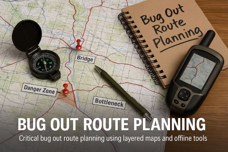
- Mapped manually (print and laminated)
- Tested at least once per year
- Clear of red flags (bridges, tunnels, city centers, checkpoints)
🧠 Pro tip: Give each route a code name (“Alpha,” “Echo,” “Delta”) for radio use or covert communication.
2. Best Tools for Bug Out Route Planning
Modern tools can give you layered risk visibility, but you also need analog backups.
🔧 Digital Tools:
| Tool | Use Case |
|---|---|
| Google Earth Pro | Satellite views, terrain analysis |
| Gaia GPS | Hiking paths, offline topo maps |
| CalTopo | Fire, slope, and water overlays |
| OpenStreetMap | Editable global map with footpaths/trails |
| Scribble Maps | Draw routes, mark hazards, export PDF |
📄 Offline Essentials:
- Topographic maps (1:50,000 or better)
- Waterproof map sleeves or laminated copies
- Compass (with declination set for your area)
- Pace beads (for walking route timing)
“Never trust only a screen when your life’s on the line.” — Off-Grid Navigation Handbook, 2022
3. Mapping Risk Zones: What to Avoid Along Your Route
When planning a bug out route, you must map the dangers, not just the roads.
🚫 Avoid These High-Risk Zones:
- Urban centers, especially commercial districts
- Government buildings, police stations, military zones
- Hospitals (often chaos during crisis)
- Major highways and known choke points
- Bridges, tunnels, and bottlenecks
- Industrial sites, chemical plants, rail yards
🔥 Use Risk Map Overlays For:
- Wildfire activity
- Floodplain boundaries
- Nuclear plant proximity
- Protest zones or active civil unrest
- Refugee or aid distribution zones (high tension)
📍 Mark every potential hazard, checkpoint, or red zone on your printed map in advance.
4. Foot-Based Bug Out Routes: When You Must Go Without a Vehicle
Your bug out strategy should assume this: at some point, you might have to walk.
Reasons you might go on foot:
- Roads blocked
- Vehicle disabled
- Fuel unavailable
- Movement needs to be stealthy
- Group is scattered
👣 Building a Foot Route:
- Use forest trails, abandoned train tracks, utility lines
- Avoid fence lines, private property, water crossings
- Mark rest points, resupply caches, water sources
- Estimate pace: 3–4 km/h loaded, less with elevation
🧠 Pro tip: Keep a preloaded hiking app like Gaia GPS or Topo Maps+ on your phone with offline mode activated — and always carry a compass + map as backup.
5. Alternative Bug Out Transportation Methods
Not everyone will escape in a well-fueled 4×4. You need to plan for flexible mobility, especially if roads are blocked or fuel runs out.
🚲 Viable Transportation Options:
| Transport Type | Pros | Cons |
|---|---|---|
| Bike (MTB) | Silent, fast, off-road capable | Limited cargo, exposed |
| Motorbike | Agile, fuel-efficient | Noise, vulnerable in crash |
| 4×4 Vehicle | Range, cargo, family mobility | Fuel, roadblock risk, visibility |
| ATV | Off-road beast, gear hauling | Fuel-heavy, not stealthy |
| On foot | Ultimate fallback | Slow, high effort, low carrying |
🧠 Tip: If using vehicles, cache fuel in safe midpoints along your routes using treated gasoline in sealed containers (with stabilizer).
6. Group Coordination: Bugging Out With Others
A route plan is meaningless if your group can’t follow or understand it. That’s why you need simple, repeatable, shared protocols.
📋 Group Route Coordination Tips:
- Share printed map packets with each member
- Assign role-based leadership (navigator, medic, scout)
- Predefine check-in points every 10–15 km
- Set visual signals (stacked stones, marked trees)
- Use coded language on comms or messages
🔗 If using radios (GMRS/FRS), designate:
- Channel
- Callsigns
- Check-in schedule (e.g., every hour on the hour)
📍 Have at least two rally points marked in case of separation.
7. The Most Dangerous Route Planning Mistakes
No matter how experienced you are, these errors can ruin even the best strategy:
❌ Don’t Make These Mistakes:
- Using only GPS — fails under signal loss or cyberattack
- Assuming roads will be open — especially bridges and highways
- Failing to test the route physically — maps lie, conditions change
- Ignoring seasonal obstacles — snow, flooding, wildfires
- Relying on one path only — need at least 3
- Underestimating fatigue — bug out bags + walking = brutal
- Skipping fuel logistics — fuel disappears in hours during crisis
🧠 Tip: Simulate an evacuation once per season. Do it with packs, at night, or in the rain to test true conditions.
8. Practice Drills and Map Exercises
Planning is good. Practicing is survival.
🧪 Route Planning Practice Ideas:
- Walk your tertiary route with a full pack and stopwatch
- Navigate 10 km without GPS, using only compass and map
- Create flashcard drills for rally points, radio codes, and signs
- Cache an item mid-route, then retrieve it after 3 months
- Do a vehicle bug out race at 4 AM with your group
📂 Build a “Mobility Binder” that includes:
- All route maps
- Contact list with radios and phones
- Vehicle maintenance checklist
- Fuel log
- Emergency detour options by zone
🔁 Review and update every 6 months minimum.
Internal Linking for Complete Strategy Integration
To build a full-spectrum plan, connect this article with:
- 🔗 The Ultimate Bug Out Strategy for 2025
- 🔗 Bug Out Bag Essentials: What You Actually Need
- 🔗 Best Bug Out Vehicle Guide
- 🔗 Free Map Downloads + Printable Checklists
9. Scenario: A Realistic Bug Out Route in Action
Let’s see what happens when a route plan is tested under pressure.
🚨 Scenario: Flash Riots + Communications Blackout
You live 25 km from a mid-sized city. After a coordinated cyberattack, the power grid fails across 3 states. Within 12 hours:
- ATMs are offline
- Grocery stores are swamped
- Gas stations ration fuel
- Unconfirmed reports of police being overwhelmed
Your group activates its bug out protocol.
🔁 Your Route Plan in Action
- You take Route Echo (your secondary): a rural backroad with 2 fuel cache points and a woodland bypass near a known choke point.
- You avoid the interstate entirely, bypassing 3 checkpoints using an unmarked gravel road.
- At kilometer 40, you hit a fallen tree. Your alternate trail (Route Delta) leads you 8 km through footpaths — slow, but safe.
You arrive 9 hours later, exhausted, but safe — with all your party intact and your gear dry.
🧠 Post-crisis lesson: Route testing, fuel cache rotation, and seasonal drills saved the mission.
FAQ: Bug Out Route Planning
How far should my bug out route be?
The ideal length for a bug out route depends on your location, threat level, and mobility — but a safe benchmark is between 50 and 150 kilometers.
Why this range?
- Under 50 km may still be within the “chaos zone” (urban panic, checkpoints, looting)
- Over 150 km may be unrealistic without fuel, vehicle, or high endurance if traveling on foot
It’s essential to consider:
- Your fitness level
- Load weight of your bug out bag
- Terrain type (flat vs mountainous)
- Seasonal factors (snow, mud, heat)
🧭 Tip: Design your route in stages, with at least one fallback point 25–40 km in. If the main destination becomes unreachable, you still have options.
What if roads are blocked or destroyed?
Yes — and this step is critical if your route relies on motorized transport or if your destination is more than a day away.
Caching fuel and supplies ensures:
- You can bypass empty gas stations
- You carry less weight in your main bug out load
- You have backup in case of theft or gear loss
🔐 Fuel Caching Tips:
- Use approved, airtight containers (metal jerry cans with stabilizer)
- Bury or conceal in PVC tubes or ammo cans, away from heat or water
- Mark the location covertly — GPS coordinates + visual memory aid (unique rock, tree)
- Rotate or refill every 6 months to prevent degradation
📦 What to Cache:
- Treated fuel (for vehicle, stove, or generator)
- Food (freeze-dried, high-calorie)
- Water or water filters
- First aid + fire tools
- Spare socks, gloves, or poncho
- Local map copy + printed instructions
🧠 Pro Tip: Hide one cache halfway through your route, and another just outside your destination, in case your base is compromised.
Should I cache fuel and supplies?
At a minimum, test your route once per season — four times a year. Each season affects your route differently:
- Winter: Snow, ice, low daylight, frozen water
- Spring: Mud, flooding, heavy undergrowth
- Summer: Heat exhaustion, dehydration, denser vegetation
- Fall: Slick leaves, changing trail visibility, early darkness
You should also vary the time of day:
Try a midday escape during peak heat and visibility
Practice a night bug out with headlamps
Test a dawn departure after zero sleep
How often should I practice my bug out route?
Timing (compare to plan)
Equipment performance
Terrain difficulty
Group coordination (if applicable)
How your body reacts to weight and distance
🧠 Pro Tip: Keep a Bug Out Drill Logbook. After each test, write down:
- Travel time
- Issues encountered
- Changes made
- What worked well
That’s how your paper plan becomes a real-world, lifesaving strategy.

